Summary: This is a moderate walk starting from the car park at Farigaig Forest, climbing to Toman Tarsuinn before reaching the halfway point in the village of Foyers. Stop here for a breather and bite to eat at the Waterfall Café or simply take advantage of the toilets in the car park area.
Distance & Grade: 9.8km. Moderate.
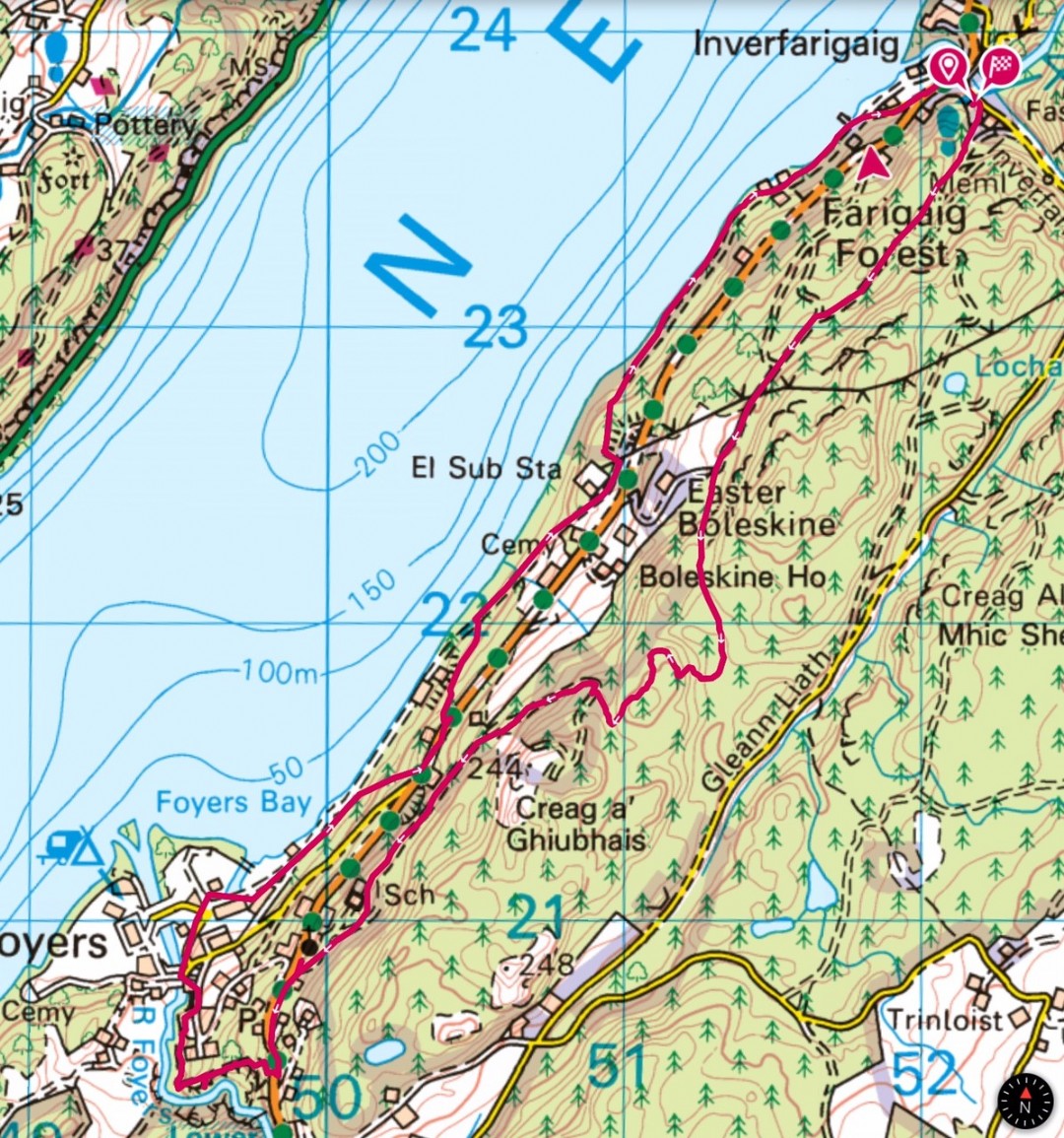 Description: Start at the Farigaig Forest car park and head steeply uphill on a rough path for a short distance before turning right on a track which will take you around a small loop to a viewpoint overlooking Loch Ness. If you are interested in geocaching you may wish to have a hunt for the cache near the bench!
After the bench continue following the narrow but well defined path through the trees which will eventually take you down to a main forestry track. Turn right here and look out for the blue South Loch Ness Trail marker posts. When you reach the large pylons, take a short diversion to the right to get a wonderful view of Meall Fuar-mhonaidh, the highest point round Loch Ness, and Foyers Bay. Continue on the main track until you come to a junction where you keep left and follow the track up a fairly steep slope through the trees until you get to Forestry Commission fingerpost and a South Loch Ness Trail blue marker. Continue straight ahead here through a fairly boggy section and up through the trees.
Again, lookout for blue marker posts and be careful when you come to the chain to help you over a short rocky section. The track continues to wind up hill. Unfortunately most of the views of Loch Ness have been obscured by trees but there are a few big flat rocks which you can scramble onto for a peak of the Loch or just sit and relax after the exertion of climbing to the highest point of Toman Tarsuinn. The track now heads downhill and after hopping across a wee burn you come to a main forestry track again. Turn right here and follow this track all the way down to the main road, B852. Be sure to look out for the shaft in a small clearing. This is a service tunnel of the Foyers pump storage Hydro scheme.
Turn left at the road and following the pavement walk the short, sharp incline to the shop, and Waterfall café in Foyers. Cross the road and follow the track signposted Upper Falls of Foyers. The falls are often spectacular but not so much after a dry spell or if SSE are drawing water off for hydroelectricity purposes. Retrace your steps before following the path round the gorge and through the trees before coming out on a track which leads to Foyers Bay House hotel. Turn left on this track downhill to the road to Lower Foyers. Turn left on this road and follow it around a right hand bend past some recycling bins and one of the Foyers to Inverness bus stops. A short way down the road on a left hand bend take the right hand turning towards the SSE power station. After the large stone building on the right (the old Foyers Aluminium Smelting factory) and opposite the boat yard, turn right onto a track with a green marker post. When the track bends to the right, take the left fork and you will soon see some very old and rickety wooden steps. Pass these and walk steadily uphill until you reach the B852 where you turn left. About halfway up this track there is a delightful wooden bench with a quirky description.
Walk along the road past Foyers Lodge hotel and just past the hotel you will see a metal fence on your left with a green Right of Way sign directing you towards Inverfarigaig via loch side route. Take this path down a steep set of steps and into woodland. Turn right, take a stile over the metal fence and continue downhill through the woods until you reach a tarmac road which is the service road for the SSE power station. Turn right on this road until you come to an SSE substation. Immediately past the substation you will see a marker post and track with some steps that lead you downhill back into woodland. As the track bends to the right, there are a lot of fallen trees ahead. To avoid these walk about 15 metres then look out for a very vague track on your right. Follow this into the woods (but don’t start climbing) and you’ll see an old grass covered forestry track. Follow this until you see a way marker and the main track again. This alternative route is only about 100m. Continue on this wider grassy path which continues all the way to Lower Birchwood.
Opposite the track to Lower Birchwood there is a small track on your left. Follow this down to the loch shore where you will find a number of seats where you can enjoy the views over the loch. Return to the main track and follow this past a number of houses to Inverfarigaig pier. This is an old Thomas Telford pier, most of which is still intact but the Victorian addition at the end has unfortunately fallen into complete disrepair. Enjoy the view across to Meall Fuar-mhonaidh and up the loch towards Urquhart Castle. Follow the tarmac road up to the B852 where you turn left and then right at the junction signposted for Errogie and return to the car park.