Summary: This is a lovely circular route for not only walkers, but runners, cyclists and horse riders as well. A mixture of minor roads, forest roads and forest tracks provide variety for everyone. At a distance of just over 17km and over 460 metres of ascent, this is a great workout for all.
Distance & Grade: 17.7km. Moderate.
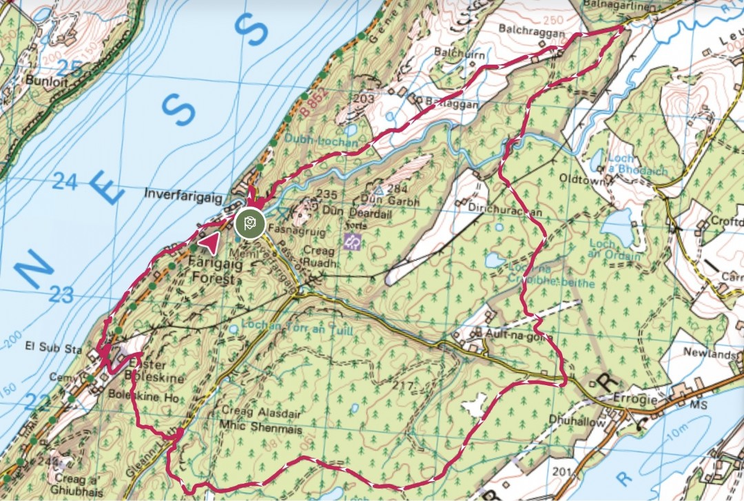 Description: Starting at the Farigaig Forest car park in Inverfarigaig head down towards the junction with the B852. Turn right then right again opposite the new houses. This road is known as the Corkscrew - it heads steeply uphill in a series of zig-zags before flattening out to a more gentle incline for approximately 3km. Finally, just past Balchraggan farm, there is respite from the uphill as the road starts to descend slightly. At a sign saying ‘heavy vehicles crossing’ turn right onto the forest road (hard packed stone) and follow this for another 3.2km until you reach a junction with the Pass of Inverfarigaig minor road.
Cross the road and continue on the forest road for a further 3.2km until you cross a wooden bridge. Shortly after the bridge the road splits - stay to the right and continue for approx 0.5km until you see on the right, a blue Trail of the Seven Lochs way-marker. Take this narrow and rough path, following it downhill and eventually across a stream to the Glen Liath minor road.
Turn right and continue down the road to a large turning area on your left. Follow the path on your left with the Right of Way marker - Foyers via hill route, Inverfarigaig via Boleskine, which initially goes fairly steeply uphill. After a short distance you will come to a wider track with a blue South Loch Ness Trail marker post and a Forestry finger post. Turn right here, following the track which, after a short way begins to head downhill. At the bottom of the track turn left and continue past a house (Easter Boleskine) and pond, down to the B852.
Turn right for a short distance before hopping over a style on your left and onto a small tarred road which heads downhill towards the electricity sub-station. Look out for a wooden Forestry marker post on your right. The first part of this section is a little challenging and care is required to navigate some fallen trees before you reach a better path alongside Loch Ness. Follow this, passing a few houses until you reach Inverfarigaig Pier. Take the road heading uphill towards the B852.Turn left then right on to the road signposted Errogie, back towards the start.